
Imray Chart A233
Imray Chart A233
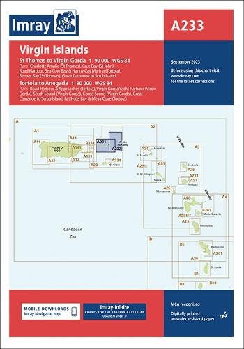
Charts A231 and A232 combined
Map
Couldn't load pickup availability
Join our rewards scheme and earn 123 reward points on this purchase!
Earn 123 points on this!
Sign in or Sign up!- Release Date: 01/09/2023
- Barcode: 9781786795151
- Genre: Science Nature & Math
- Sub-Genre: Earth Sciences

Imray Chart A233
Couldn't load pickup availability
Collapsible content
DESCRIPTION
Charts A231 and A232 combined
This edition includes the latest official data combined with additional information sourced from Imray''s network to make it ideal for small craft. It includes the latest official bathymetric surveys. There has been general updating throughout.
Plans included: Charlotte Amalie (St Thomas) (1:30 000) Cruz Bay (St John) (1:20 000) Road Harbour, Sea Cow Bay & Nanny Cay Marina (Tortola) (1:20 000) Benner Bay (St Thomas) (1:30 000) Great Camanoe to Scrub Island (1:20 000) Road Harbour & Approaches (Tortola) (1:20 000) Virgin Gorda Yacht Harbour (Virgin Gorda) (1:20 000) South Sound (Virgin Gorda) (1:20 000) Gorda Sound (Virgin Gorda) (1:25 000) Fat Hogs Bay & Maya Cove (Tortola) (1:20 000) Imray-Iolaire charts for the Caribbean are widely acknowledged as the best available for the cruising sailor. They combine the latest official survey Digital with first-hand information gathered over 60 years of research by Don Street Jr and his wide network of contributors. Like all Imray charts, they are printed on water resistant Pretex paper for durability, and they include many anchorages, facilities and inlets not included on official charts. This edition includes the latest official Digital combined with additional information sourced from Imray's network to make it ideal for small craft. It includes the latest official bathymetric surveys. There has been general updating throughout.
DELIVERY & RETURNS
UK Delivery:
- Free delivery on all orders of £10 or more.
- £1.49 delivery fee on orders below £10.
- UK orders are shipped via Royal Mail 2nd Class.
International Delivery:
- Flat rate delivery charges vary by country.
Dispatch and Delivery Times:
- All orders are shipped from our warehouse in Northampton, UK within 48 hours of receipt during working hours.
- UK mainland orders typically arrive within 3-5 working days via Royal Mail 2nd Class.
- International estimated delivery times:
- Europe & Channel Islands: 7 to 10 working days
- USA: 7 to 15 working days
- Rest of the World: 9 to 21 working days
View our full delivery infomation here.
-
OVER
2 MILLION PRODUCTS
-
60 MILLION CUSTOMERS
ACROSS 190 COUNTRIES
You might also like
Loading recommendations...