
La Loire Eurovelo 6
La Loire Eurovelo 6
Cycling Map
Map
Couldn't load pickup availability
Join our rewards scheme and earn reward points on this purchase!
Earn points on this!
Sign in or Sign up!- Release Date: 29/11/2016
- Barcode: 9783943752007
- Genre: Science Nature & Math
- Sub-Genre: Atlases & Maps

La Loire Eurovelo 6
Standard Edition
Couldn't load pickup availability
Collapsible content
DESCRIPTION
Cycling Map
A new handy cycling route atlas. Choose your route using the free mini map enclosed & follow your progress using the atlas. Includes practical & emergency information, with complete and detailed mapping.
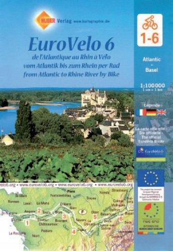
EuroVelo Route No. 6 in a six-map set covering the French part of this trans-European cycle route: from the Atlantic along the Loire, the Canal du Centre, the Saone, the Doubs and the Canal du Rhone au Rhin to the Rhine at Basel. The route is presented on six double-sided, GPS compatible maps at 1:100,000 published by Huber Verlag with funding from the European Union.The overprint highlighting the route and its variants indicates traffic-free sections, roads with heavy motorized traffic, different types of surface and gradients, as well as intermediate and cumulative distances. For larger towns detailed street plans are provided including, where appropriate, alternative routes across their centres (Nantes, Angers, Tours, Orleans, Nevers, Chalon-sur-Saone, Besancon, Mulhouse and Basel).Exceptionally clear cartography, with relief shading and spot heights to show the topography, presents the road and rail networks of the surrounding countryside. Symbols highlight various places of interest including cycle repair and/or rental, campsites and youth hostels, tourist information offices, sport and recreational facilities, museums, etc. The maps have a 5-km UTM grid for GPS users. Map legend includes English.Our maps are regularly updated even if the ISBN does not change.(Edition updated in 2017)
DELIVERY & RETURNS
UK Delivery:
- Free delivery on all orders of £10 or more.
- £1.49 delivery fee on orders below £10.
- UK orders are shipped via Royal Mail 2nd Class.
International Delivery:
- Flat rate delivery charges vary by country.
Dispatch and Delivery Times:
- All orders are shipped from our warehouse in Northampton, UK within 48 hours of receipt during working hours.
- UK mainland orders typically arrive within 3-5 working days via Royal Mail 2nd Class.
- International estimated delivery times:
- Europe & Channel Islands: 7 to 10 working days
- USA: 7 to 15 working days
- Rest of the World: 9 to 21 working days
View our full delivery infomation here.
-
OVER
2 MILLION PRODUCTS
-
60 MILLION CUSTOMERS
ACROSS 190 COUNTRIES
You might also like
Loading recommendations...