
WK 051 Eisenwurzen - Steyr - Waidhofen a.d. Ybbs - Hochkar,
WK 051 Eisenwurzen - Steyr - Waidhofen a.d. Ybbs - Hochkar,
Map
Couldn't load pickup availability
Join our rewards scheme and earn reward points on this purchase!
Earn points on this!
Sign in or Sign up!- Release Date: 20/07/2020
- Barcode: 9783850848015
- Genre: Sports & Hobbies
- Sub-Genre: Sport & Outdoor Recreation
- Publisher: Freytag-Berndt
WK 051 Eisenwurzen - Steyr - Waidhofen a.d. Ybbs - Hochkar,
Couldn't load pickup availability
Collapsible content
DESCRIPTION
freytag & berndt maps are available for many countries and regions in the world. In addition to the precise cartography each map also includes a lot of additional information about the region covered.
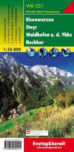
The WK 051 Eisenwurzen - Steyr - Waidhofen ad Ybbs - Hochkar, hiking map 1:50,000 is regularly revised and contains updated information on hiking trails, cycling and mountain bike trails, huts, natural monuments, cultural sights and leisure facilities. The enclosed information booklet contains a selection of the best hiking trails, cycle paths and mountain bike routes as well as a brief description of the individual communities and their leisure activities. (Language: German) Leisure information, hiking and long-distance hiking trails, mountain bike and cycling tours, register of places with postcodes, GPS-compatible, via ferrata, bridle path, ski route, cross-country route, Nordic walking route; Region: Eisenwurzen, Mostviertel, Traunviertel, Ybbstal; Special themed hiking trails: Eisenwurzenweg, long-distance hiking trail of the Lions Clubs, Kalkalpenweg, Rafters' Trail, Ybbstal circular route, Luchstrail; Special cycle and mountain bike tours: Enns Cycle Path, National Park Limestone Alps Cycle Path, Stiftsblick Cycle Route, Ybbstal Cycle Path, Through the Reichraminger Hintergebirge, Sonnbrand Alm Tour; Environment maps: WK 031, WK 041, WK 052, WK 054, WK 062, WK 081, WK 082; Thanks to the detailed digital cartography and the precise scales, freytag & berndt hiking maps are ideal companions for hiking, mountaineering and ski tours. WK 082; Thanks to the detailed digital cartography and the precise scales, freytag & berndt hiking maps are ideal companions for hiking, mountaineering and ski tours. WK 082; Thanks to the detailed digital cartography and the precise scales, freytag & berndt hiking maps are ideal companions for hiking, mountaineering and ski tours.
DELIVERY & RETURNS
UK Delivery:
- Free delivery on all orders of £10 or more.
- £1.49 delivery fee on orders below £10.
- UK orders are shipped via Royal Mail 2nd Class.
International Delivery:
- Flat rate delivery charges vary by country.
Dispatch and Delivery Times:
- All orders are shipped from our warehouse in Northampton, UK within 48 hours of receipt during working hours.
- UK mainland orders typically arrive within 3-5 working days via Royal Mail 2nd Class.
- International estimated delivery times:
- Europe & Channel Islands: 7 to 10 working days
- USA: 7 to 15 working days
- Rest of the World: 9 to 21 working days
View our full delivery infomation here.
-
OVER
2 MILLION PRODUCTS
-
60 MILLION CUSTOMERS
ACROSS 190 COUNTRIES
You might also like
Loading recommendations...