
Wind River Range South Map (Lander, Cirque of the Towers)
Wind River Range South Map (Lander, Cirque of the Towers)
Trails Illustrated Maps
Map
Couldn't load pickup availability
Join our rewards scheme and earn reward points on this purchase!
Earn points on this!
Sign in or Sign up!- Release Date: 21/08/2021
- Barcode: 9781566958271
- Genre: Sports & Hobbies
- Sub-Genre: Travel Guides
- Imprint: National Geographic
Wind River Range South Map (Lander, Cirque of the Towers)
Reprint
Couldn't load pickup availability
Collapsible content
DESCRIPTION
Trails Illustrated Maps
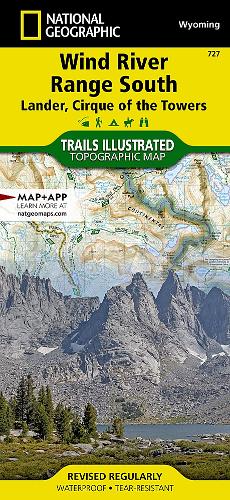
• Waterproof • Tear-Resistant • Topographic MapThe Wind River Range of northwest Wyoming encompasses an area of more than 3,500 square miles. Locally known as just 'The Winds', the range contains a unique combination of jagged granite rock, alpine forest, open meadows, over 1,300 named lakes, and the largest glacier in the American Rockies. Recreation opportunities are distributed across the landscape with hiking, camping, fishing, climbing and snowmobiling to list just a few.The map is centered on the southern section of the Wind River Range. The Popo Agie Wilderness and a large section Bridger Wilderness are clearly shown with the Continental Divide running through the middle of the map. The glaciers and countless lakes make this map a must-have for visitors entering from Lander. The Continental Divide Trail transects this area on its way from Mexico to Canada. The map also includes Cirque of the Towers, a nearly circular ring of jagged peaks towering over Lonesome Lake.The Wyoming State Department of Fish and Game provides data on known fish presence for the thousands of lakes that appear on this map. Each lake with fish is highlighted to help anglers find just the right spot. Each section of trail includes mileage information to help with planning and steep sections of trail are marked so hikers will know what to expect on their trip.Every Trails Illustrated map is printed on 'Backcountry Tough' waterproof, tear-resistant paper. A full UTM grid is printed on the map to aid with GPS navigation.Other features found on this map include: Atlantic Peak, Big Sandy Lodge, Bridger Wilderness, Bridger-Teton National Forest, Buckskin Crossing, The Bus Trails, Cirque of the Towers, Dickinson Park, Fiddlers Lake, Johnny Behind the Rocks, Lizard Head Peak, Louis Lake, Middle and North Fork Popo Agie Rivers, Popo Agie Wilderness, Ray Lake, Red Canyon, Roaring Fork Mountain, Shoshone National Forest, Sinks Canyon State Park, South Pass City, Sweetwater, Washakie Pass, Wind River Peak, Wolverine Peak. Scab Creek, Worthen Meadow Reservoir.
DELIVERY & RETURNS
UK Delivery:
- Free delivery on all orders of £10 or more.
- £1.49 delivery fee on orders below £10.
- UK orders are shipped via Royal Mail 2nd Class.
International Delivery:
- Flat rate delivery charges vary by country.
Dispatch and Delivery Times:
- All orders are shipped from our warehouse in Northampton, UK within 48 hours of receipt during working hours.
- UK mainland orders typically arrive within 3-5 working days via Royal Mail 2nd Class.
- International estimated delivery times:
- Europe & Channel Islands: 7 to 10 working days
- USA: 7 to 15 working days
- Rest of the World: 9 to 21 working days
View our full delivery infomation here.
-
OVER
2 MILLION PRODUCTS
-
60 MILLION CUSTOMERS
ACROSS 190 COUNTRIES
You might also like
Loading recommendations...