
Delaware Water Gap National Recreation Area Map
Delaware Water Gap National Recreation Area Map
Trails Illustrated Maps
Map
Couldn't load pickup availability
Join our rewards scheme and earn reward points on this purchase!
Earn points on this!
Sign in or Sign up!- Release Date: 30/05/2013
- Barcode: 9781566956291
- Genre: Science Nature & Math
- Sub-Genre: Atlases & Maps
- Imprint: National Geographic
Delaware Water Gap National Recreation Area Map
Standard Edition
Couldn't load pickup availability
Collapsible content
DESCRIPTION
Trails Illustrated Maps
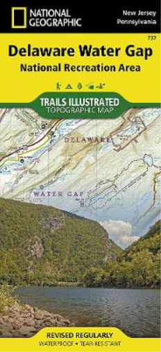
• Waterproof • Tear-Resistant • Topographic MapExplore and discover new wonders with National Geographic's Trails Illustrated map of Delaware Water Gap National Recreation Area. Created in partnership with local land management agencies, this expertly researched map delivers unmatched detail and helpful information for paddlers, anglers, hikers, and other adventurers looking to explore the 70,000-acre park. The area's unique terrain, with low-forested mountains and 1,000-foot deep water gap, is the map's core feature, with detailed elevation contours, shaded relief, vegetation, and water features. Some of the key areas of interest included are Middle Delaware River; High Point, Swartswood, and Kittatinny Valley state parks; and Stillwater Natural Area. With miles of mapped trails including portions of the Appalachian, Liberty Gap, and Joseph M. McDade trails, this map can guide you off the beaten path and back again. Trail mileage between intersections will help you choose the path that's right for you. River mileage and rapids on the Middle Delaware River are noted for those exploring by boat. Hiking, biking, and horse trails, along with major and secondary roads, are clearly distinguished. Boundaries for park lands, wilderness, and protected areas are color-coded and easy to discern. Some of the many recreation features shown include campgrounds, climbing areas, boat ramps, canoe access, and scenic areas. A trail chart and featured trails summary, as well as handy activity and waterfalls charts are included as well. Every Trails Illustrated map is printed on 'Backcountry Tough' waterproof, tear-resistant paper. A full UTM grid is printed on the map to aid with GPS navigation.Other features found on this map include: Coolbaugh, Delaware Water Gap, East Stroudsburg, High Point, Kittatinny Mountain, Neversink River, Swartswood Lake.
DELIVERY & RETURNS
UK Delivery:
- Free delivery on all orders of £10 or more.
- £1.49 delivery fee on orders below £10.
- UK orders are shipped via Royal Mail 2nd Class.
International Delivery:
- Flat rate delivery charges vary by country.
Dispatch and Delivery Times:
- All orders are shipped from our warehouse in Northampton, UK within 48 hours of receipt during working hours.
- UK mainland orders typically arrive within 3-5 working days via Royal Mail 2nd Class.
- International estimated delivery times:
- Europe & Channel Islands: 7 to 10 working days
- USA: 7 to 15 working days
- Rest of the World: 9 to 21 working days
View our full delivery infomation here.
-
OVER
2 MILLION PRODUCTS
-
60 MILLION CUSTOMERS
ACROSS 190 COUNTRIES
You might also like
Loading recommendations...