
Corsica Map (France)
Corsica Map (France)
Adventure Maps
Map
Couldn't load pickup availability
Join our rewards scheme and earn reward points on this purchase!
Earn points on this!
Sign in or Sign up!- Release Date: 22/02/2012
- Barcode: 9781566956062
- Genre: Science Nature & Math
- Sub-Genre: Atlases & Maps
- Imprint: National Geographic
Corsica Map (France)
Couldn't load pickup availability
Collapsible content
DESCRIPTION
Adventure Maps
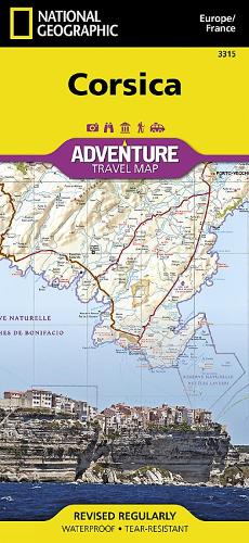
• Waterproof • Tear-Resistant • Travel MapExplore the most mountainous island in the Mediterranean and discover while it's called the 'isle of beauty' with National Geographic's Corsica Adventure Map. Cities and towns are clearly indicated and easy to find in the user-friendly index. A road network complete with distances and designations for major roads, expressways, scenic routes, and secondary roads will help you find the route that's right for you. The popular GR 20 trail is noted for advanced hikers looking to traverse one of the most beautiful mountain trails in Europe. With specialty content to include hundreds of diverse and unique recreational, ecological, cultural, and historical destinations, this map is a perfect companion to a guidebook. Beaches, winter sports resorts, golf courses, spas, castles, churches, camping areas, and UNESCO World Heritage sites are clearly indicated so travelers can take advantage of Corsica's many natural attractions and activities. The locations of airports, airfields, harbors, marinas, and ferry routes take the guesswork out of travel around the island.The front side of the print map details the northern region of this island country; bordering Golfe de Sagone and Golfe de Porto to the west, Tyrrhenian Sea to the east, and the Ligurian Sea and Golfe de St.-Florent to the north. The reverse side of the map shows the southern region; from its border with the Bouches de Bonifacio to the south, to the Tyrrhenian Sea, Golfe de Santa-Manza and Golfe de Porto-Vecchio to the east, and the Mediterranean Sea, Golfe de Sagone, Golfe de Valinco and Golfe d' Ajaccio to the west. This island is located west of Italy, southeast of the French mainland and north of the Italian island of Sardinia. Every Adventure Map is printed on durable synthetic paper, making them waterproof, tear-resistant and tough — capable of withstanding the rigors of international travel.
DELIVERY & RETURNS
UK Delivery:
- Free delivery on all orders of £10 or more.
- £1.49 delivery fee on orders below £10.
- UK orders are shipped via Royal Mail 2nd Class.
International Delivery:
- Flat rate delivery charges vary by country.
Dispatch and Delivery Times:
- All orders are shipped from our warehouse in Northampton, UK within 48 hours of receipt during working hours.
- UK mainland orders typically arrive within 3-5 working days via Royal Mail 2nd Class.
- International estimated delivery times:
- Europe & Channel Islands: 7 to 10 working days
- USA: 7 to 15 working days
- Rest of the World: 9 to 21 working days
View our full delivery infomation here.
-
OVER
2 MILLION PRODUCTS
-
60 MILLION CUSTOMERS
ACROSS 190 COUNTRIES
You might also like
Loading recommendations...