
Boston Harbor Islands National Recreation Area Map
Boston Harbor Islands National Recreation Area Map
Trails Illustrated Maps
Map
Couldn't load pickup availability
Join our rewards scheme and earn reward points on this purchase!
Earn points on this!
Sign in or Sign up!- Release Date: 02/08/2012
- Barcode: 9781566955751
- Genre: Science Nature & Math
- Sub-Genre: Atlases & Maps
- Imprint: National Geographic
Boston Harbor Islands National Recreation Area Map
Standard Edition
Couldn't load pickup availability
Collapsible content
DESCRIPTION
Trails Illustrated Maps
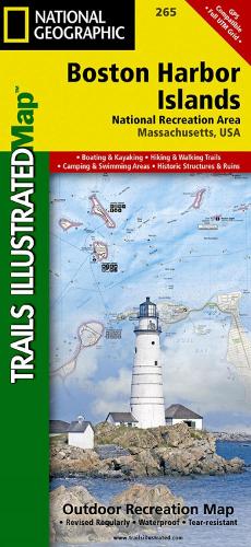
• Waterproof • Tear-Resistant • Topographic MapLocated just outside of downtown Boston, the Boston Harbor Islands provide an abundance of recreational opportunities for all outdoor enthusiasts. Expertly researched and created in cooperation with the National Park Service, Boston Harbor Islands Alliance and many others, National Geographic's Trails Illustrated map of Boston Harbor Islands National Recreation Area is an essential travel companion for all visitors to the area. The front side of the map contains both topography and bathymetry, while the reverse side shows the area in high-resolution satellite imagery. Together they provide unparalleled detail of all 34 harbor islands, shorelines, downtown Boston and neighboring communities, Boston Inner Harbor and the other waterways that surround the islands.Mainland piers with park operated ferries to the islands are clearly marked along with their facilities as well as water taxi stations. Boaters will find boat ramps, docks, moorings, buoys, beacons and soundings. Background information of many of the islands is provided along with hiking and biking trails, available facilities and pinpointed structures, buildings and other points of interest. Other recreational features noted include areas for fishing, swimming, diving, canoeing, kayaking, cross-country skiing, wildlife viewing, camping and picnicking. The map also provides a complete road network of the area along with subway, commuter rail stations.Every Trails Illustrated map is printed on 'Backcountry Tough' waterproof, tear-resistant paper. A full UTM grid is printed on the map to aid with GPS navigation.Other features found on this map include: Boston, Charles River, Hingham, Hull, Milton, Quincy, Winthrop.
DELIVERY & RETURNS
UK Delivery:
- Free delivery on all orders of £10 or more.
- £1.49 delivery fee on orders below £10.
- UK orders are shipped via Royal Mail 2nd Class.
International Delivery:
- Flat rate delivery charges vary by country.
Dispatch and Delivery Times:
- All orders are shipped from our warehouse in Northampton, UK within 48 hours of receipt during working hours.
- UK mainland orders typically arrive within 3-5 working days via Royal Mail 2nd Class.
- International estimated delivery times:
- Europe & Channel Islands: 7 to 10 working days
- USA: 7 to 15 working days
- Rest of the World: 9 to 21 working days
View our full delivery infomation here.
-
OVER
2 MILLION PRODUCTS
-
60 MILLION CUSTOMERS
ACROSS 190 COUNTRIES
You might also like
Loading recommendations...