
Dinosaur National Monument Map
Dinosaur National Monument Map
Trails Illustrated Maps
Map
Couldn't load pickup availability
Join our rewards scheme and earn reward points on this purchase!
Earn points on this!
Sign in or Sign up!- Release Date: 02/08/2012
- Barcode: 9781566954037
- Genre: Science Nature & Math
- Sub-Genre: Atlases & Maps
- Imprint: National Geographic
Dinosaur National Monument Map
Reprint
Couldn't load pickup availability
Collapsible content
DESCRIPTION
Trails Illustrated Maps
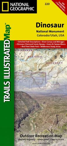
• Waterproof • Tear-Resistant • Topographic MapNational Geographic's Trails Illustrated map of Dinosaur National Monument, which straddles the state lines of northwest Colorado and northeast Utah, is the perfect recreational map for this stunning monument. Within its craggy hills, you can discover pieces of a long ago world where the largest land creatures of all time once roamed and died. Expertly researched and created in partnership with local land management agencies, this map features key points of interest including Dinosaur Quarry, Red Fleet State Park, Canyon of Lodore, Harpers Corner, and the town of Dinosaur. The map also highlights many popular routes for scenic driving including Dinosaur Diamond, Harpers Corner, Tour of the Tilted Rocks, Browns Park, and Jones Hole. This map features detailed topography with shaded relief, elevations, easy-to-read trails, and clearly defined, color-coded boundaries for parks, wildlife study areas, public lands, and areas of critical environmental concern. Information about the region, its history and culture, geology, and natural history are provided as well. Those exploring by boat will appreciate the inclusion of river campsites, river mileage and access points along the Yampa and Green rivers. Other recreation features noted include campgrounds, boat launches, interpretive trails, fishing access, scenic viewpoints, and visitor centers.Every Trails Illustrated map is printed on 'Backcountry Tough' waterproof, tear-resistant paper. A full UTM grid is printed on the map to aid with GPS navigation.Other features found on this map include: Canyon of Lodore, Diamond Gulch, Dinosaur, Douglas Mountain, Split Mountain, Yampa River.
DELIVERY & RETURNS
UK Delivery:
- Free delivery on all orders of £10 or more.
- £1.49 delivery fee on orders below £10.
- UK orders are shipped via Royal Mail 2nd Class.
International Delivery:
- Flat rate delivery charges vary by country.
Dispatch and Delivery Times:
- All orders are shipped from our warehouse in Northampton, UK within 48 hours of receipt during working hours.
- UK mainland orders typically arrive within 3-5 working days via Royal Mail 2nd Class.
- International estimated delivery times:
- Europe & Channel Islands: 7 to 10 working days
- USA: 7 to 15 working days
- Rest of the World: 9 to 21 working days
View our full delivery infomation here.
-
OVER
2 MILLION PRODUCTS
-
60 MILLION CUSTOMERS
ACROSS 190 COUNTRIES
You might also like
Loading recommendations...