
Fontana and Hiwassee Lakes Map (Nantahala National Forest)
Fontana and Hiwassee Lakes Map (Nantahala National Forest)
Trails Illustrated Maps
Map
Couldn't load pickup availability
Join our rewards scheme and earn reward points on this purchase!
Earn points on this!
Sign in or Sign up!- Release Date: 01/01/2020
- Barcode: 9781566953337
- Genre: Science Nature & Math
- Sub-Genre: Atlases & Maps
- Imprint: National Geographic
Fontana and Hiwassee Lakes Map (Nantahala National Forest)
Standard Edition
Couldn't load pickup availability
Collapsible content
DESCRIPTION
Trails Illustrated Maps
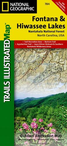
• Waterproof • Tear-Resistant • Topographic MapNestled in between the Cherokee and Chattahoochee National Forests, lies Nantahala National Forest with its abundance of recreational opportunities. National Geographic's Trails Illustrated map of Fontana and Hiwassee Lakes delivers unmatched detail and valuable information to assist you in your exploration of this forest. Expertly researched and created in cooperation with the U.S. Forest Service and others, this map features popular points of interest including Nantahala and Chatuge Lakes; Joyce Kilmer Slickrock and Citico Creek Wilderness areas; and Snowbird and Unicoi Mountains.Handy activity guides with help you narrow down areas to visit according to your needs and interests. Trail charts, with hundreds of miles of trails, will help you choose a trail that's right for your activity level and recreation use whether you're hiking, horseback riding, mountain biking, or ATVing, The Appalachian, Benton MacKaye and Bartram Trails are all highlighted. Mountain Waters, Indian Lakes, Nantahala and Cherohala Skyway Scenic Byways are noted for those wishing to explore the region by car. To aid in your navigation, the map also displays shaded relief, contour lines with elevations, water features and areas of private land. Some of the many recreation features noted include campgrounds and campsites, boat ramps and marinas, river and whitewater access points, fishing and swimming areas, lookout towers, wildlife viewing areas and scenic overlooks. Provided also are background information of Nantahala National Forest and Appalachian Trail, bear safety tips and essential contact information. Every Trails Illustrated map is printed on 'Backcountry Tough' waterproof, tear-resistant paper. A full UTM grid is printed on the map to aid with GPS navigation.Other features found on this map include: Chattahoochee National Forest, Chatuge Lake, Cheoah Mountains, Cherokee National Forest, Citico Creek Wilderness, Fontana Lake, Great Smoky Mountains, Haw Knob, Hiwassee Lake, Joyce Kilmer-Slickrock Wilderness, Nantahala Mountains, Nantahala National Forest, Snowbird Mountains, Southern Nantahala Wilderness, Unicoi Mountains, Valley River Mountains.
DELIVERY & RETURNS
UK Delivery:
- Free delivery on all orders of £10 or more.
- £1.49 delivery fee on orders below £10.
- UK orders are shipped via Royal Mail 2nd Class.
International Delivery:
- Flat rate delivery charges vary by country.
Dispatch and Delivery Times:
- All orders are shipped from our warehouse in Northampton, UK within 48 hours of receipt during working hours.
- UK mainland orders typically arrive within 3-5 working days via Royal Mail 2nd Class.
- International estimated delivery times:
- Europe & Channel Islands: 7 to 10 working days
- USA: 7 to 15 working days
- Rest of the World: 9 to 21 working days
View our full delivery infomation here.
-
OVER
2 MILLION PRODUCTS
-
60 MILLION CUSTOMERS
ACROSS 190 COUNTRIES
You might also like
Loading recommendations...