
Moab Area (Map Pack)
Moab Area (Map Pack)
Trails Illustrated Maps
Map
Couldn't load pickup availability
Join our rewards scheme and earn reward points on this purchase!
Earn points on this!
Sign in or Sign up!- Release Date: 11/02/2022
- Barcode: 9781566959117
- Genre: Non-Fiction
- Sub-Genre: Sports & Hobbies
- Imprint: National Geographic
Moab Area (Map Pack)
Reprint
Couldn't load pickup availability
Collapsible content
DESCRIPTION
Trails Illustrated Maps
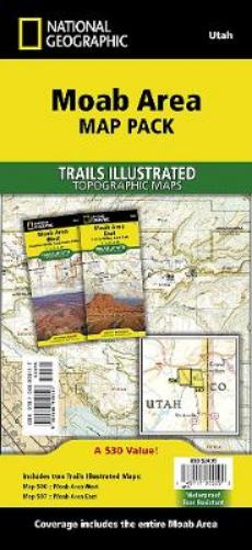
• Waterproof • Tear-Resistant • Topographic MapsA premier destination for mountain biking, hiking, whitewater rafting, four-wheeling, and more, Moab offers adventure and recreation in one of the most iconic landscapes in the United States. National Geographic's Trails Illustrated maps of Moab were created in partnership with local land management agencies and adventure experts to provide unmatched detail of the area, with useful up-to-date information to guide and enrich your visit. On the Moab Area East and West maps, particular attention is given to the area's extensive mountain bike trail systems, which are clearly mapped and labeled. Trails are symbolized by use (hiking, mountain biking, OHV), with trail difficulty indicated for mountain bike trails. Trail segments are labeled with distances between junctions, and all trailheads and trail junctions are labeled with elevations. 4x4 trails are highlighted in yellow with notes for obstacles and features along the route. Group, primitive, and developed campgrounds are shown with their amenities, and the total number of sites. Colorado River access points and mileages are mapped and labeled for river recreation. Visitor centers, interpretive trails, and scenic overlooks are prominently mapped and labeled with their amenities. OHV, biker, and desert safety tips, laws, and etiquette are also provided.Buy the Map Pack and save 15%!The Moab Area Map Pack includes: • Map 506 :: Moab Area West • Map 507 :: Moab Area EastEvery Trails Illustrated map is printed on 'Backcountry Tough' waterproof, tear-resistant paper. A full UTM grid is printed on the map to aid with GPS navigation.
DELIVERY & RETURNS
UK Delivery:
- Free delivery on all orders of £10 or more.
- £1.49 delivery fee on orders below £10.
- UK orders are shipped via Royal Mail 2nd Class.
International Delivery:
- Flat rate delivery charges vary by country.
Dispatch and Delivery Times:
- All orders are shipped from our warehouse in Northampton, UK within 48 hours of receipt during working hours.
- UK mainland orders typically arrive within 3-5 working days via Royal Mail 2nd Class.
- International estimated delivery times:
- Europe & Channel Islands: 7 to 10 working days
- USA: 7 to 15 working days
- Rest of the World: 9 to 21 working days
View our full delivery infomation here.
-
OVER
2 MILLION PRODUCTS
-
60 MILLION CUSTOMERS
ACROSS 190 COUNTRIES
You might also like
Loading recommendations...