
Colorado River, Headwaters to Kremmling Map
Colorado River, Headwaters to Kremmling Map
Fishing and River Map Guides
Map
Couldn't load pickup availability
Join our rewards scheme and earn reward points on this purchase!
Earn points on this!
Sign in or Sign up!- Release Date: 30/10/2018
- Barcode: 9781566957571
- Genre: Science Nature & Math
- Sub-Genre: Atlases & Maps
- Imprint: National Geographic
Colorado River, Headwaters to Kremmling Map
Standard Edition
Couldn't load pickup availability
Collapsible content
DESCRIPTION
Fishing and River Map Guides
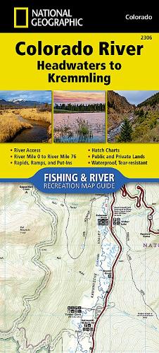
• Waterproof • Tear-Resistant • Fishing & River MapThe Colorado River, Headwaters to Kremmling Fishing & River Map Guide is designed to be the perfect companion for anyone recreating on the upper section of this mighty river. Traveling approximately 76 miles and dropping just shy of 3,000 feet in elevation, the section of the upper Colorado River represented in this map—from its headwaters to Kremmling—winds through diverse landscapes, passes near the towns of Granby, Hot Sulphur Springs, Kremmling, and Parshall, supporting a variety of ecosystems as it morphs into a powerful and mighty waterway known for prolific insect life; brown, rainbow, and brook trout (and the occasional cutthroat); wildlife viewing opportunities; and superb cultural and historical features.Offering copious chances for recreation, including camping; stellar angling; and unguided rafting, kayaking, and stand-up paddle boarding on the Fraser River between Tabernash and Granby and through Byers Canyon (a classic Class IV run on the Colorado River), this waterway and its tributaries—which are the lifeblood of the basin—draw nature lovers, explorers, and anglers from across the globe seeking to experience the Colorado's world-class fly-fishing, spectacular scenery, and remarkable adventure opportunities. Each Fishing & River Map Guide includes detailed river maps at a scale of 1 inch = 1/2 mile. At this scale every turn in the river and rapid is clearly shown and labeled. Each page is centered on the river and overlaps with the adjacent pages so finding any location along the river is easy. The maps include rapids, river miles, access points, private and public lands, gaging stations, recreation sites, and more. Also included are stream flow charts, hatch charts, and a table of river access points.More convenient and easier to use than folded maps, but just as compact and lightweight, National Geographic's Fishing & River Map Guide booklets are printed on 'Backcountry Tough' waterproof, tear-resistant paper with stainless steel staples. A full UTM grid is printed on the map to aid with GPS navigation.
DELIVERY & RETURNS
UK Delivery:
- Free delivery on all orders of £10 or more.
- £1.49 delivery fee on orders below £10.
- UK orders are shipped via Royal Mail 2nd Class.
International Delivery:
- Flat rate delivery charges vary by country.
Dispatch and Delivery Times:
- All orders are shipped from our warehouse in Northampton, UK within 48 hours of receipt during working hours.
- UK mainland orders typically arrive within 3-5 working days via Royal Mail 2nd Class.
- International estimated delivery times:
- Europe & Channel Islands: 7 to 10 working days
- USA: 7 to 15 working days
- Rest of the World: 9 to 21 working days
View our full delivery infomation here.
-
OVER
2 MILLION PRODUCTS
-
60 MILLION CUSTOMERS
ACROSS 190 COUNTRIES
You might also like
Loading recommendations...